Navigating the Extreme Climate: Identifying High-Risk Areas for Floods Due to Extreme Rainfall and Implementing Mitigation Measures in Western Java, Indonesia
Navigating the Extreme Climate: Identifying High-Risk Areas for Floods Due to Extreme Rainfall and Implementing Mitigation Measures in Western Java, Indonesia
(GF | 13/03/2024)
1. Introduction to Western Java Extreme Climate
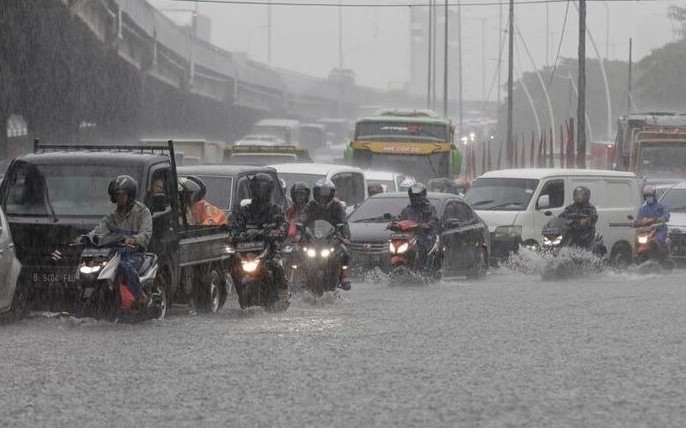
Western Java, a hub for economic activities, governmental systems, and agricultural products, holds a central position in the national perspective. However, news from Kompas notes that West Java has become the province with the highest incidence of disasters in Indonesia, especially hydro-meteorological disasters throughout 2023. These disasters include floods, landslides, storms, and other extreme weather.
One significant aspect of hydro-meteorological disasters is flooding due to extreme rainfall. Events of extreme rainfall can be influenced by various factors, such as climate change, atmospheric circulation, topography, and others. The Intergovernmental Panel on Climate Change (IPCC) predicts an increase in the frequency, intensity, and duration of extreme rainfall as a consequence of climate change (IPCC, 2013). A deep understanding of the dynamics of extreme climate becomes crucial in facing the escalating threat of disasters. This article aims to highlight the escalation of potential threats from extreme rainfall in western Java and the mitigation efforts that can be taken.
2. Into the Data, Knowing the Trend and Pattern of the Extreme Rainfall
The western Java is located in the middle of the Asia-Australia monsoon route. This results in clear differences in rainfall patterns between the wet and dry seasons. The complexity of the topography influences the rainfall patterns in each region (Qian’s, 2008). Differences in the distribution of topography in western Java led to non-homogeneous spatial patterns of rainfall. Highland areas tend to have higher intensity of rainfall than lowland areas.
Based on daily rainfall data from meteorological stations in western Java for the last 40 years, an analysis of spatial patterns and trends in extreme rainfall was carried out. Referring to the research of the Expert Team Climate Change Detection and Indices (ETCCDI), the RX1d index was chosen which represents extreme rainfall intensity. This index is defined as the maximum intensity of rainfall in one year. The analysis results show that the highland areas have a higher intensity of extreme rainfall than the lowland areas except for the Bandung basin area as shown in Figure 1.

An analysis of extreme rainfall intensity in western Java shows a significant increase in the past 20 years. As many as 57.35% of the 335 stations in western Java were identified as experiencing an increase in rainfall intensity every year, especially in Bogor, Cirebon, Sukabumi, and Tasikmalaya areas as shown in Figure 2. This finding is in line with research conducted by Avia (2019) using TRMM data that indicates the trend of extreme rainfall is increasing, especially in the Southern Part of Java. Climate change may lead to a more pronounced increase in the intensity of extreme rainfall.
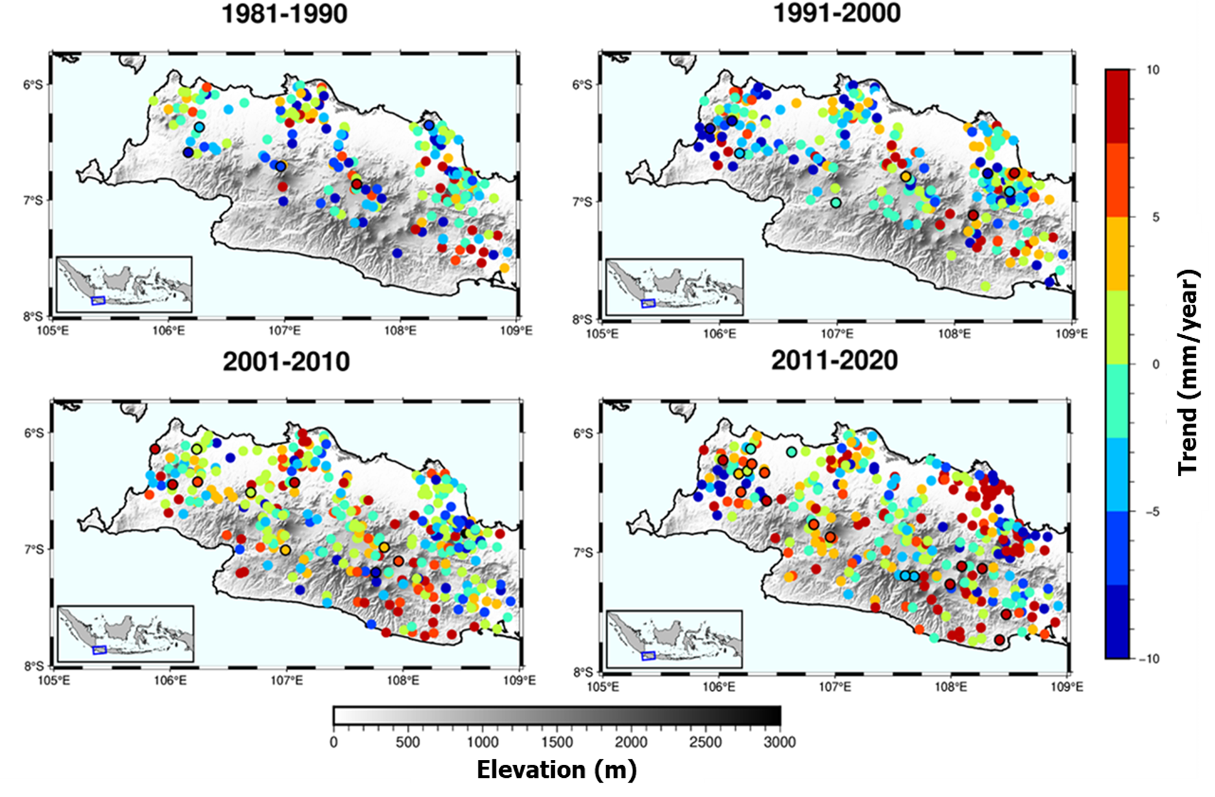
According to the analysis of spatial patterns and trends in extreme rainfall, areas such as Bogor, Cirebon, Sukabumi, and Tasikmalaya require heightened vigilance against potential flood disasters. Nevertheless, it is crucial to note that flood risks due to extreme rainfall may emerge in other regions, emphasizing the need for continuous awareness across various areas.
3. Indonesia’s Action to Prepare Against the Worst Rainfall
An early warning system is a vital component in mitigating flood disasters caused by extreme rainfall. The occurrence of floods that affected three districts in Cirebon Regency in 2020 showed the effectiveness of the Flood Early Warning System (FEWS) in minimizing the impact of disasters. FEWS issues a warning once the river water surpasses the threshold level. Hence, through collaboration with the community, the local disaster response team can evacuate swiftly and efficiently, ensuring no casualties and minimizing property damage.
However, the distribution of FEWS devices is still insufficient for the number of flood-prone areas. Referring to the 2019 budget, only 25 districts and cities throughout Indonesia received installations of these devices. In West Java Province, there are approximately 21 districts/cities vulnerable to flood disasters. Moreover, the early warning system for extreme weather developed in 2021 operates around 30 minutes before the incident, not aligning with the standard operating procedures of the disaster response task force, which requires 1 to 3 hours. Therefore, a comprehensive flood early warning system, that provides information on event timing at least the next 3 hours, becomes an urgent necessity. The collaboration between BNPB, BMKG, BRIN, PUPR, and Bappenas, aligned with the national disaster management plan for 2020-2024, represent a strategic approach to effective and responsive flood mitigation, particularly in high-risk areas.
It is important to involve private companies and academics to accelerate the development of FEWS. For that calling, PT Bhumi Warih Geohydromatics, a private company in Indonesia specializing in hydrodynamics, weather, and climate, has developed a FEWS strategy for 2024. We see FEWS not only as a program, but assurance for safety of people, assets, and the industries.
References
[1] Avia, L. Q. (2019, November). Change in rainfall per-decades over Java Island, Indonesia. In IOP Conference Series: Earth and Environmental Science (Vol. 374, No. 1, p. 012037). IOP Publishing.
[2] Field, C. B., Barros, V. R., Dokken, D. J., Mach, K. J., Mastrandrea, M. D., Bilir, T.E., … & White, L. L. (2013). Contribution of Working Group I to the Fifth Assessment Report of the Intergovernmental Panel on Climate Change. Climate Change, 1800-1820.
[3] Qian, J. H. (2008). Why precipitation is mostly concentrated over islands in the Maritime Continent. Journal of the Atmospheric Sciences, 65(4), 1428-1441.
[4] Jaelani, G. F. (2022). Analysis of Characteristics Extreme Rainfall Trends in Western Java, Indonesia Based on Insitu Data. Bandung Institute of Technology, Bandung, Indonesia.
[6] https://perpustakaan.bnpb.go.id/bulian/index.php?p=show_detail&id=1993
[7] https://bnpb.go.id/berita/fews-bpbd-kabupaten-cirebon-selamatkan-warga-dari-bahaya-banjir
[8] https://www.bnpb.go.id/storage/app/media/uploads/24/katalog-desa-kelurahan-rawan-banjir.pdf
[9] http://etccdi.pacificclimate.org/indices_def.shtml
[10] https://www.indonesiawaterportal.com/news/indonesia-on-alert-against-heavy-rain-and-floods-1.html
