Breaking the Cycle of Dredging: A Smart Sedimentation Solution for River Delta Systems
(AR | 18/12/2025)
When sediment refuses to stay where it belongs, industries pay the price. Around the world, rivers and estuaries deliver not only water but also sand, silt, and mud, materials that slowly but relentlessly clog and disrupt critical infrastructures. Dredging can buy time, but it never wins the war. Each scoop of removed sediment material is eventually replaced by the next tide. This is the challenge faced by many operations within dynamic river delta systems.
An industrial water intake system in a river with high sediment levels experienced frequent sediment buildup right in front of its intake. Fine sand and silt were repeatedly transported toward the structure during tidal cycles and periods of elevated river discharge, gradually reducing intake efficiency and increasing the risk of blockage. Although routine dredging temporarily restored operability, sediment re-accumulated within a short period, indicating that the intake was located within an active sediment transport and deposition zone. This recurring pattern demonstrated that conventional dredging alone was insufficient to resolve the underlying sedimentation mechanism.
To break this cycle, a sedimentation assessment was conducted to identify the key drivers of sediment build-up and to develop an engineering-based solution capable of reducing dredging frequency while ensuring the intake remained safe and operational.
How did we do it?
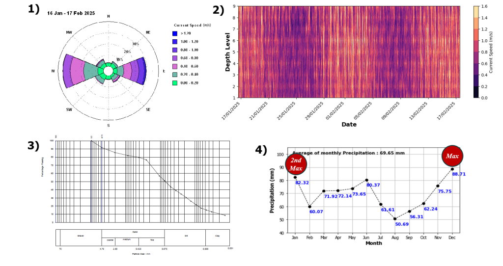
The study began with a detailed investigation of the river’s natural dynamics. A comprehensive field survey collected measurements of currents, tides, bathymetry, and sediment characteristics, revealing the system’s governing processes. Historical rainfall data were analyzed to understand seasonal variability, while wave climate assessments evaluated offshore forcing. In addition, the configuration of pile structures near the intake was examined to determine whether man-made features were unintentionally steering sediment toward the intake area. These datasets and analyses are illustrated in Figure 1.
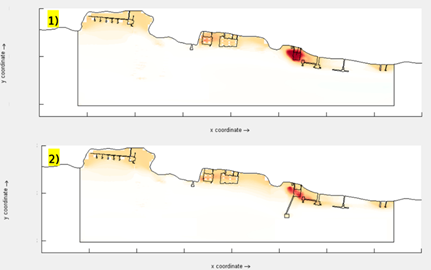
Using the collected data, a high-resolution numerical model (up to 1 m) was developed to simulate hydrodynamics and sediment transport. This virtual reconstruction of the river enabled multiple scenarios to be tested without disturbing real-world conditions. Among the strategies evaluated, relocation of the water intake emerged as the most effective option. To protect sensitive site and design information, the intake locations and structural details shown in the following illustration are intentionally anonymized and presented in a generalized form.
Modeling results indicate that relocating the intake can reduce sediment accumulation by up to four times compared to existing conditions, as illustrated in Figure 2. In the existing condition, sediment deposition concentrates around the intake, forming a persistent accumulation zone. In contrast, the alternative configuration positions the intake outside this zone, resulting in lower sediment build-up and more stable bed conditions. At the original intake, sedimentation could reach approximately 300 m³ per month, whereas the same-sized area at the proposed location is projected to accumulate approximately 80 m³ per month. This reduction represents a major decrease in dredging needs while also improving long-term operational stability, reducing operational risk, and lowering maintenance costs.
The benefits of this approach extend beyond cost savings. A more stable intake system enhances operational reliability and safety, while reduced dredging minimizes disturbance to the surrounding river delta environment. With fewer dredging activities, machinery in the water is reduced, noise levels decline, emissions decrease, and the ecological footprint becomes smaller. This proves that smart engineering can benefit both industry and nature.
This study highlights how the integration of comprehensive field data with advanced numerical modeling can transform a challenging sedimentation problem into a clear, actionable strategy. By combining scientific analysis with predictive modeling, the study demonstrates a smarter and more proactive approach to understanding sediment behavior. Showing how data-driven science can outsmart natural forces and break the cycle of costly dredging.
If your operation faces sedimentation challenges such as blocked intakes, reduced navigational depth, or unexpected sediment build-up, why rely on short-term fixes? With the right data and engineering approach, sediment movement can be predicted, managed, and mitigated before it disrupts operations. Let’s work with nature, not against it. Contact us at bw@bwgeohydromatics.com to develop a smarter, long-term sedimentation solution.
