Mysterious Swell from Land Direction
Mysterious Swell from Land Direction
(AN | 23/11/2022)
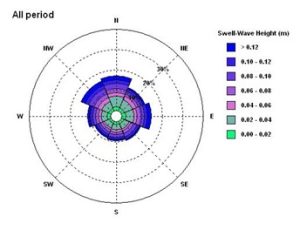
Before proceeding to the main idea, we dare you to have a glance in the rose plot of swell wave height below. Do you notice any anomaly? Or further, can you guess the geographical location of this swell observation?
The location of data record looks like in the middle of the sea with swell almost equally propagating from all directions. However, the truth is the data was recorded from 5 km Northwest of the Java Island. Now the question is: how the instrument recorded swell from Southwest where it is very close to shore?
Swells are not generated by local winds blowing. Instead, they are the result of the interaction of severe storms with a large fetch of water that takes place in the open ocean, miles away from the landmasses. A storm acts like a pebble dropped in a pond, sending out ripples of energy in concentric circles. The longer and harder the wind blows, the bigger the ocean swell.
Swell contributes to wave height and characteristics. Such waves affect our coasts and activities of all kinds which we pursue at the coast, near the coast and out to sea. Therefore, wave analysis is much needed for offshore work, especially in design criteria and risk analysis. There are several ways to obtain wave data. The most common and reliable way is through field observation using Acoustic Doppler Current Profiler (ADCP).
The ADCP measures water currents with sound, using a principle of sound waves called the Doppler effect. The ADCP works by transmitting “pings” of sound at a constant frequency into the water. (The pings are so highly pitched that humans and even dolphins can’t hear them.) As the sound waves travel, they ricochet off particles suspended in the moving water and reflect back to the instrument. From a technical and oceanographic perspective against the wave period, with ADCP we can observe: ripples (waves with a period between crests of up to second), waves (undulations with a period between crests of between one and ten seconds), and swells (groups of waves with a period between crests of more than ten seconds).
Now back to our rose plot earlier, is it possible that this ADCP instrument captured swell that is propagating from land? There are several possibilities to answer this question:
a. Swell wave reflection due to a massive jetty
Through a we identified a km length of massive jetty located around 10 km southwest from the ADCP location. This infrastructure may cause wave reflection thus the ADCP recorded swell that is propagating from the jetty.
b. Shoreline reflection
Another possible explanation s from a research paper regarding the shoreline effect to wave reflection. Ardhuin and Rolland (2012) suggest that the effect of shoreline reflection of swell wave may reduce the directional spreading error which tends to be neglected in wave simulation. This study also shows that adding the shoreline reflection coefficient (R) improved the result of the simulation. Thus, it is possible for the ADCP to record swell from land direction due to shoreline wave reflection.
c. Vessel wave
Didenkulova and Rodin et. al (2012) found that in the case of n Bay, the vessel movement could wake a vessel wave with wave period 8 – 15 s and wave height up to 1 m. If this also the case, it could affect the wave recording as the lowest swell period found in the ADCP data is 7.5 s.
Anyhow the discussion is still open. If you are interested, find us at: metocean@bwgeohydromatics.com
References:
Ardhuin, F., and Roland, A. (2012), Coastal wave reflection, directional spread, and seismoacoustic noise sources, J. Geophys. Res., 117, C00J20, doi:10.1029/2011JC007832.
Rodin, Artem & Didenkulova, I. (2012). A typical wave wake from high-speed vessels: Its group structure and run-up. Nonlinear Processes in Geophysics. 20. 752-. doi:10.5194/npg-20-179-2013.


